


Land and Lot Photography in Wells, ME
WHAT WE DO
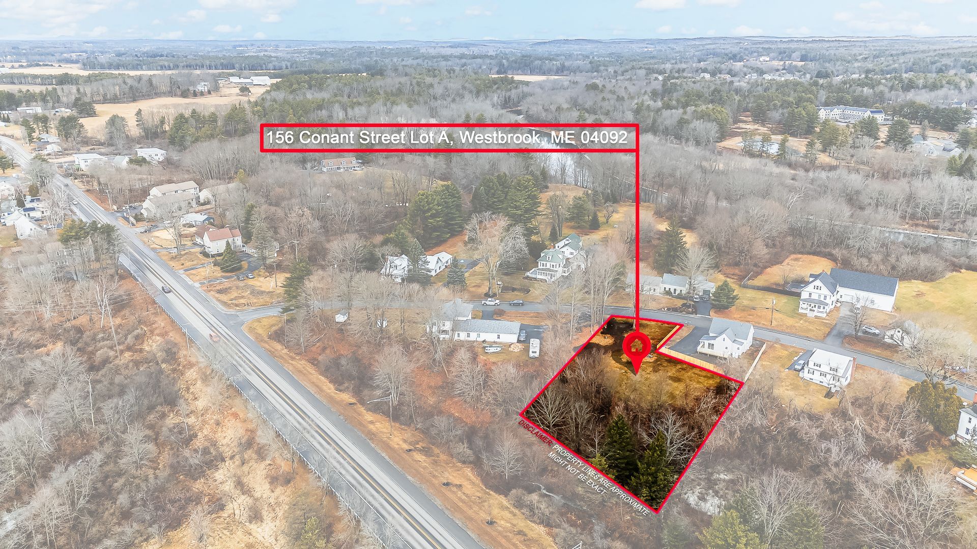
Property lines only become legal through a licensed survey, so overlays on aerial photographs are illustrative and get labeled that way. Mile Fly Club Aerials
handles land and lot photography across Wells, ME
and the Seacoast into New Hampshire, flagging corners on site, flying the parcel under a Part 107 certificate, and delivering wide landscape frames buyers can actually read.
WHERE WE SCOUT
Acreage, Frontage, And The Line Of The Trees
Vacant land is the hardest thing to sell from a photograph, because there is no front door to point a camera at. A wooded lot reads as a wall of trees from the road. A field looks like every other field. What buyers need is shape: where the frontage runs, where the driveway could go, how the ground rises, where the wet areas sit. We walk and fly parcels from inland Maine to the New Hampshire Seacoast, planning each shoot around season, sun angle, and how much leaf cover hides the ground.
Land Photography Services We Provide
Land needs a different plan than a house. Coverage is built to answer the questions a buyer will ask about access, boundaries, terrain, and what could realistically be built there.
01
Boundary and Overview Aerials
One wide anchor frame shows the whole parcel with approximate boundaries drawn in and the adjacent roads labeled. It becomes the image buyers return to, because it answers shape, size, and orientation before any other question even arises.
02
Road Frontage and Access Documentation
Frames along the road show frontage width, curb cuts, any existing driveways, and how a vehicle would actually reach the site itself. Access is often the very first thing a buyer or builder wants confirmed about raw land.
03
Topography and Elevation Coverage
Low sun angles reveal the subtle grade changes that a flat midday frame hides completely. Passes across slopes, knolls, and low ground help buyers understand where a foundation could sit and where water is most likely to collect.
04
Tree Cover and Clearing Potential
Aerial frames show canopy density, existing clearings, stone walls, and the old logging roads running through a parcel. Buyers evaluating a building site need to know how much clearing stands between them and a genuinely usable house lot.
05
Water, Wetland, and View Frames
Ponds, streams, marsh edges, and any distant water views all get their own dedicated coverage. Elevated frames also help show whether a second story on the site would capture a view that is completely invisible from ground level today.
06
Seasonal and Repeat Coverage
The same parcel photographs very differently in June and in November. Repeat visits across the seasons give a listing fresh imagery through the year and let buyers see the land both with foliage and without it before committing.
Jane Faber
This is the text area for this paragraph. To change it, simply click and start typing. Once you've added your content, you can customize its design.
Jane Faber
This is the text area for this paragraph. To change it, simply click and start typing. Once you've added your content, you can customize its design.
Jane Faber
This is the text area for this paragraph. To change it, simply click and start typing. Once you've added your content, you can customize its design.
TESTIMONIALS
What Our Customers Say
Why Choose Us for Land and Lot Photography
Photographing land badly is easy: a few flat frames of grass and trees that could be almost anywhere. Making a parcel understandable takes real planning, height, and an honest approach to boundaries.
01
Corners Flagged Before The Flight
Markers go out on the ground first, so the aerial frames all have real reference points in them. Overlays drawn afterward follow those markers rather than approximating a line from a tax map and hoping it looks close.
02
Boundaries Labeled Honestly
Every overlay is presented as approximate and subject to a survey. That protects the seller from a dispute later, and it tells a serious buyer they are dealing with someone who truly understands the limits of a photograph.
03
Height Chosen To Show Shape
Altitude is set by what the parcel itself needs to communicate. A small building lot reads best from low passes, while larger acreage needs the height that puts road, boundary, and tree line together in a single frame.
04
Light Timed To Reveal Terrain
Early and late sun rakes low across the ground and makes every grade change clearly visible. Midday light instead flattens a parcel into a featureless green rectangle that tells a buyer almost nothing useful about the site itself.
05
Frames Sized For Every Listing Field
Land listings live across the MLS, specialist land marketplaces, and print flyers. Files arrive in landscape orientation and at exactly the resolutions that those platforms expect, so nothing gets cropped awkwardly or rejected at the point of upload.
06
Rural Airspace Checked Just As Carefully
Remote does not ever mean unregulated. Rural parcels get exactly the same airspace screening and authorization process that coastal properties do, so a flight over open farmland is just as compliant as one over a quiet village street.
WHO WE ARE
Ground Truth Before Anything Gets Drawn
We flag corners on site before flying, so a boundary overlay follows something real rather than a guess made later at a desk. Overlays are always labeled approximate, because only a licensed surveyor establishes a line. That honesty protects the seller as much as the buyer. Every flight runs under an FAA Part 107 Remote Pilot Certificate, insured, with airspace cleared beforehand for rural parcels just as carefully as for coastal ones. Send the parcel details and a map link through our contact page to begin.
Frequently Asked Question
How do you photograph vacant land so buyers understand the size?
Wide aerial frames anchor the listing and show the whole parcel clearly against its surroundings. Corners get flagged on the ground first, and ground-level shots then cover frontage, access, and terrain so acreage stops feeling abstract to buyers.
Can property lines be added to aerial photos of a lot?
Lines can be added, and buyers find them useful, but the result is illustrative only. Boundaries are established legally through a licensed survey, so any overlay we deliver is clearly labeled as approximate and subject to later verification.
What time of day is best for photographing acreage?
Shoot in the hour after sunrise or the hour just before sunset. Mile Fly Club Aerials times parcel visits around that light near Wells, Maine, because midday sun flattens contours, drainage, and ground texture into a single tone.
What season is best to photograph land for sale?
Season depends entirely on what needs showing. Bare trees in late fall reveal the terrain, stone walls, and sight lines, while summer foliage shows privacy and shade. Many listings genuinely benefit from having both sets of images available.
Should photos of land be horizontal or vertical?
Horizontal, almost always. Landscape framing conveys the expanse, the layout, and the relationship between road frontage and depth. Vertical frames get reserved for tall features such as mature pines or a steep bank sitting behind the building site.
How do you show road frontage and access on a listing?
Coverage runs along and then across the frontage, showing overall width, curb cuts, and any existing driveway or right-of-way. An elevated shot from above then places that access point in proper context with the rest of the parcel.
Do the same drone rules apply over rural farmland?
Yes, entirely and always. The 400-foot ceiling, visibility minimums, and airspace authorization requirements do not relax simply because a parcel happens to be remote. Mile Fly Club Aerials screens every rural address around Wells, Maine before scheduling a flight.
Should the corners be marked before the shoot?
It helps enormously. Cones, flags, or stakes placed at each of the corners give the camera something real to work from, which produces a far more accurate overlay than tracing a boundary line from memory back at a desk.
Why Choose Mile Fly Club Aerials
Creating Powerful Visuals From Every Angle
01
Certified, Insured, and Safety Focused
We are FAA Part 107 certified and properly insured, giving our clients confidence that every commercial drone flight is handled safely and professionally. We carefully plan each project around airspace, weather, lighting, and property conditions to produce dependable results.
02
Complete Ground and Aerial Media
We provide professional real estate photography, drone imagery, aerial video, reels, twilight photos, and specialty content in one convenient service. By capturing properties from multiple perspectives, we help buyers better understand the layout, surroundings, features, and overall value.
03
Personal, Local Service
We work directly with every client and tailor each shoot to the property, project, and intended audience. Because we know the Maine and New Hampshire Seacoast, we understand how to showcase coastal homes, land, rentals, construction projects, and local businesses.
04
Polished and Reliable Results
We deliver clean, professionally edited media designed to attract attention across listings, websites, and social media. Our dependable communication, thoughtful preparation, and timely delivery make it easier for clients to market their properties and businesses confidently.
Make Raw Land Easy To Picture And Easy To Buy
Buyers rarely struggle to imagine a finished house on a lot. What stops them on a land listing is not knowing where the driveway would enter, how far back the trees run, or whether the ground drops away behind the frontage. Answer those questions with clear aerial and ground-level coverage and a parcel stops competing on price alone. Mile Fly Club Aerials photographs lots, acreage, and buildable land throughout Wells, ME and across the Seacoast, with corners flagged and boundaries drawn responsibly. Send the parcel details through our contact page and we will plan the visit around the season and the light.